Hwy 18 / Big Bear Lake to I-10 / Cabazon (56.6 PCT miles)

High desert landscape and cloud drama south of Big Bear

The first of three rainbows over the desert on a stormy day in the San Bernadino Mountains
The rain forecast for overnight hadn't yet materialized on the morning of Day 115, though the sky was grey and menacing. With a crackling fire in the great room of the hostel and fresh-baked biscuits with strawberry jam for breakfast it was tempting to stay on. Instead, we loaded our backpacks in the car and headed back out to Hwy 18, arriving in time to be on-trail before 10am. We started hiking through Pinyon pines and sage, and soon came across several Joshua Trees that highlighted just how close the San Bernadino Mountains are to the desert that surrounds them. The day was windy with fast-moving clouds above, and it wasn't long before we were hiking in blustery rain. We stopped to put on our rain jackets, and I even wore gloves for about 20 minutes, but it never rained very hard or for very long. My sister, who lives just one county south in Riverside, checked in with us to see how we were faring in the weather. She told us not to go thinking that it always rains in SoCal just because we've had two big storms in the space of one week, adding that we were just "super super lucky" to get this great weather. Although there are some inconveniences to hiking and camping in the rain and wind, I'd generally have to agree with her. We saw three different rainbows in the first few hours of hiking out of Big Bear, and the dramatic sky made for a much more interesting landscape. I'm not a fan of the heat, and I'll always take a cool day for hiking, especially through areas with minimal shade. The recent rain also kept down the dust on the trail, and it was great to see blades of green grass already starting to poke up through the soil.

A Jeffrey pine forest along Arrastre Creek
We climbed along Arrastre Creek into a forest of Jeffrey pine and White fir, leaving the high desert plants behind us. The rain stopped by early afternoon but the sky filled in with low clouds that stayed for the rest of the day bringing a damp chill to the air. We continued our climb towards Onyx Summit, roughly paralleling and not far from the Rim of the World Scenic Byway (AKA Hwy 38). We were surprised by the volume of traffic on this rural road on a stormy weekday. As we got above 8000' we found ourselves walking through white granite, Lodgepole pines, and mountain mahogany and really felt like we were back in the mountains. We camped at Coon Creek Cabin our first night out of Big Bear, a relatively short distance but perfect given the inclement weather and our late start. This group camp site is just above the Coon Creek Jumpoff, a dramatic narrow canyon with 2000' high sheer rock walls that must make for quite a cascade if Coon Creek ever has water. We could see the city lights of desert communities far below, but had the trail and campsite to ourselves.

Morning golden hour in the higher elevations as we climb towards San Gorgonio

New growth along the trail through the Lake Fire burn zone

More severe destruction from the Lake Fire in the upper Mission Creek drainage
We got our usual early start on Day 116 and started our morning with a climb towards the ridgeline. The trail skirts the periphery of the Lake Fire burn zone, and was just re-opened this July following last year's fire. We noticed that while the hillsides looked black on first glance, there were many living trees scattered across the slopes. It seemed that, in this area at least, the fire was not nearly as intense as the Blue Cut Fire and the forest probably had a better chance of recovery. There were some lingering clouds from yesterday's storm and they made a spectacular backdrop for these steep hills in the morning light. We traversed high on the ridge for several miles, marveling at the intense white of the rocks and the gnarled trunks of the mountain mahogany that was the predominant tree along this stretch. We worked our way towards the shoulder of San Gorgonio Mountain, the tallest mountain in southern CA, though never had particularly impressive views of its peak from the trail. Although there was evidence of a recent fire with many burned trees, we were again impressed by how much of the forest had survived within the burn area. This stretch had many thriving manzanita, plenty of intact Jeffrey pines, and more blooming wildflowers than we have seen since early in northern CA. We have high hopes for a rapid recovery in this area. Beyond Mission Springs Camp the trail follows the drainage of the North Fork Mission Creek and here we saw more complete destruction. For 3-4 miles the steep canyon walls were uniformly charred. All of the conifers were dead and/or down, and the brush and deciduous trees were pale skeletons. The trail here was a muddy sooty rut, with some erosion and debris flow present. Even so, most of the burned brush already had a clump of new growth around its base, and the hillsides were covered in dry grass that must have regrown since the fire. We transitioned from the burn zone into a small band of mature oaks, then walked through a stretch of poodle dog bush and chaparral before descending into high desert terrain.

Lush growth along the North Fork of Mission Creek

Canyon walls as we descend along Mission Creek
By the time we first crossed Mission Creek below the burn zone we had already lost 2500' in elevation from our high point of the day. Looking up the canyon we finally had decent views of San Gorgonio mountain, the namesake of this wilderness area, but all around us were plants and rocks of the high desert. Some high clouds persisted but did little to moderate the heat of the day. The warmer temperatures combined with rare humidity proved challenging as we made a steady descent through this long canyon. Fortunately the numerous creek crossings brought ample opportunity to collect water, and there was a decent amount of shade from trees growing along the banks. The creek itself was small, but it is still a novelty to walk along running water for so many miles in the desert of SoCal. The canyon is made up of numerous rocky fingers, so the trail make several twists and turns to get around them and it was hard to get a sense of how much further we had to descend. Early on we could see the imposing dark San Jacinto range rising to the south, but as we dropped in elevation our only views were of the dramatic rock of the canyon walls themselves. Eventually the small channel of the creek became an algae-filled trickle, and before we left the canyon at around 3000' in elevation it had dried up completely in the sandy desert.

Evening golden hour and long views on the ridges between the North and West Forks of Mission Creek
After nearly 9 miles of meandering along North Fork Mission Creek, we made a sharp turn to the west to climb out of the canyon and onto the ridge separating that drainage from the one carrying the West Fork (when it has water, which it currently doesn't). From this vantage we suddenly had a full view of San Jacinto Peak, an impressive dark mountain rising from the desert floor that we immediately nicknamed the Incredible Hulk. We couldn't stop looking at it, knowing that tomorrow we would start a long climb up its impossibly tall and steep shoulder. The peaks of our own mountain range, the San Bernadinos, glowed orange in golden hour light as we followed tall trail marker posts along the spine of the ridge then dropped down to the canyon of the West Fork. Our final climb took us to the ridge overlooking the Whitewater River, and even at dusk it was a stunning sight. The river is named for the pale sandy canyon floor braided by multiple channels of water (not for any rapids along the way), and this wide white flat expanse made quite a contrast against the red-orange and purple hills on either side. We descended into the river valley by headlamp, crossed each silty channel on stepping rocks, and headed downstream towards the Whitewater Preserve where we would camp for the night.

A new plant that is prolific on the dry slopes around 2000', whose silvery grey foliage is striking in early morning light
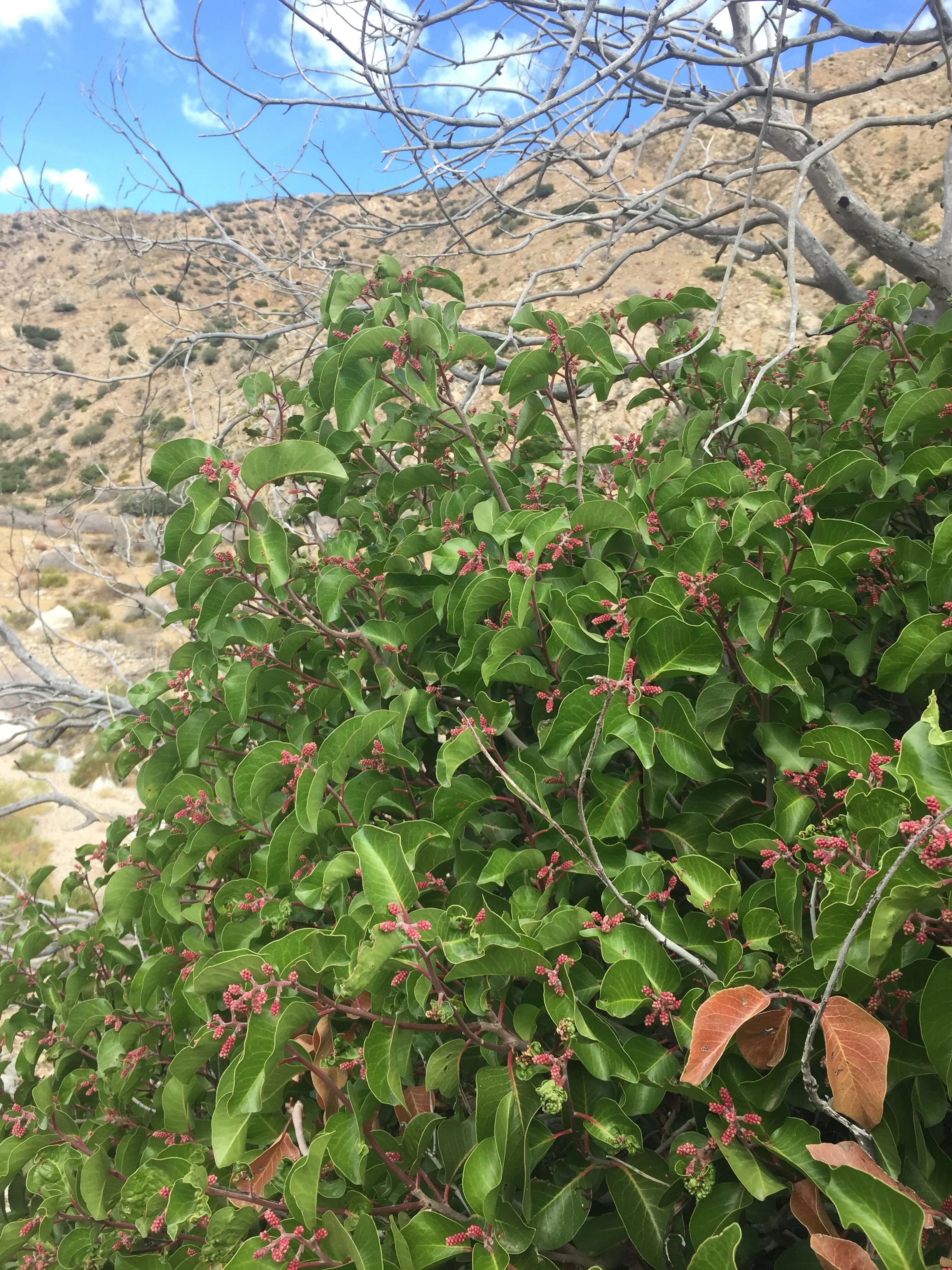
We call this one pinkberry, for obvious reasons. Initially we mistook it for a manzanita but as we saw more and more it's clearly quite different.

A new cactus as we approach the low desert

This one's prickly like most, but has flower stalks that resemble lettuce
The flora of this stretch has been impressive in its diversity. The San Bernadinos are a small mountain range, and we did not expect to find such a wide variety of ecosystems. We walked through high desert forest, high elevation conifers, oak-covered slopes, riparian terrain, and into the low desert. Nearly 30 miles of the PCT in this area passes through the newly designated Sand to Snow National Monument, and along Mission Creek we walked past the southernmost stand of quaking aspen known to exist. In the higher elevations we saw many "old friends" from other mountain ranges along the PCT, and as we dropped to the lowest elevations we've covered in the SoCal section we started to see completely new plants. There are several types of cactus we hadn't seen before, and also many new flowers and types of brush. Of course we don't know the names of anything, so we make up descriptive nicknames. One we call "pinkberry," another is "lettuce flower," and yet another is "rat bastard." Most of these desert plants have stiff branches, thorns, or both. "Rat bastard" is particularly deceptive because although it has fine frilly leaves, between each set of leaves is a thick and pointy thorn. It got its nickname from hanging over the trail far too often!

A reality nature show in progress, pre-dawn in the Whitewater Preserve. Starring one baby rattlesnake and an unfortunate desert rat.
We have also enjoyed the fauna, as usual. In the higher elevations near San Gorgonio we were surprised to find Clark's nutcrackers, the first time we've seen them since the Sierra Nevada. In the long waterless stretches of SoCal we haven't seen any amphibians, but toads were everywhere along the Whitewater River and we had to be careful not to step on them as we hiked our final miles by headlamp on a warm desert evening. Along Mission Creek we startled a bird in a stand of maples near the water and were surprised to see a large and beautiful raptor rise from the branches. We aren't certain what it was, but from a bird identification book we think it might have been a Cooper's Hawk. We also saw our second rattlesnake of the trip, a young guy right in the middle of the trail. He apparently thought there wouldn't be hikers that early, so he was using the spot to swallow his meal of some unfortunate kangaroo rat. We've seen a few other snakes, and as usual about a million lizards every day.

So many turbines at the Mesa wind farm were idle on a pretty windy day that we wondered if the farm was still in operation

Helpful trail rock at Whitewater Preserve, near PCT mile 218. We are almost done!

The most artistic trail magic dumpster we've ever seen. We might have sat on the couch if it wasn't raining.

One sad brown bear unlucky enough to have landed at "Predators of the Wild"
In southern CA, the PCT is never far from various trail neighbors. There are dirt (and paved) roads everywhere, and the trail often abuts or even crosses private land. Through this stretch of trail we've been appreciative of some really good neighbors. Beyond Onyx Summit the manager of Cienega Ranch (a former PCT hiker) installed a water pump and faucet along a dirt road so that thru-hikers would have a reliable water source between Big Bear and Mission Springs Camp. Water is precious, but potable water is like liquid gold. We gladly walked 0.3 miles off-trail to this faucet, and cooked dinner nearby before filling up and heading off to our dry camp at Coon Creek. Several places along the trail on Day 115 we came across small water caches, each jug dated and tied to a tree to prevent blow-aways. The containers were marked "You're almost to Campo! From the Big Bear mountain biking community." Bicycles are not allowed anywhere on the PCT and there is sometimes tension around this regulation, so it was especially nice to see this gesture from cyclists. Although we didn't need ware in any of these spots, we always love people who remember the SOBOs! The Whitewater Preserve was another great neighbor. This private conservation area (www.wildlandsconservancy.org) on the site of an old trout farm near the trail is a gateway to the new Sand to Snow Monument, and welcomes PCT hikers. We camped on their grounds at no charge and enjoyed picnic tables, running water, and very nice bathrooms - well worth the 0.6 bonus miles each way. Some well-meaning neighbors are trail angels from Big Bear who post their contact info at Onyx Summit. It's great for NOBOs, but not so helpful for SOBOs who have likely just left town. Likewise, we came across a couch and an artsy dumpster painted "magic" along a dirt road just before the summit. We didn't expect to find anything inside so late in the season, and sure enough it was just some Kleenex and lotion, and a note from the folks who run the Big Bear Hostel about transportation into town and places to stay & eat. Apparently they stock the magic dumpster with treats twice weekly during NOBO season. It's generous of them but not particularly useful for SOBOs. The Mesa wind farm near I-10 seemed like an absentee landlord. Despite a sign on the trail pointing to their office offering shade and water, the outdoor faucet has been capped off. Their office hours are supposedly 9a-2p, but a fellow hiker recently stopped in mid-week at 1pm to find the building deserted and locked. No water, and no shade other than that of the building itself. Fortunately we didn't need water, so we walked right on by. Every neighborhood has a sketchy place, and in this stretch of trail it was a site marked "Animal Cages" on one set of maps, and "Private Zoo" on another. The trail passes right along a tall chain link fence posted liberally with Keep Out signs, and others promising an armed response to trespassers. Apparently it is a facility that sources exotic animals for film and television (www.predatorsinaction.com), but what we saw were two sad bears in small concrete & chain link pens, with no evidence of enrichment or any attempt to provide a comfortable habitat. We were happy to see that all of the other pens seemed to be empty, though we didn't get too close as we didn't want to risk that armed response. This seemed to be one trail neighbor we could do without.

Morning glow looking north over the pale valley of the Whitewater River


That's "Goodbye, Section C" for SOBOs! Section B, here we come.

It's looking stormy over the San Jacinto range looking across I-10 as we come down out of the foothills
On Day 117 we left the Whitewater Preserve just before dawn to take advantage of the cooler morning hours, though it was already warm at that low elevation and humid in the river valley. We climbed immediately over the west ridge of the canyon and had spectacular views in every direction as the sky exploded with pinks, oranges, and reds in a classic desert sunrise. Once on the ridge we found ourselves in an area decimated by cattle. None were around, but there were cow pies everywhere, the vegetation was eaten down to the ground, and the earth was trampled. There were numerous parallel trails on each of the loose hillsides so we used the tall trail marker posts to help guide us as to which were created by cattle and which were originally meant to be trail. The dry hills were beautiful at a distance, if you didn't look closely at the destruction, and we were a little shocked that grazing is allowed in wilderness areas when this is the result. In any case, we made a final climb to about 3000' over a saddle to exit the San Gorgonio wilderness, and started a steep descent towards the wind turbines around San Gorgonio Pass on I-10. The final approach was reminiscent of several other SoCal highway crossings. We walked past wind turbines, sage-covered hills, crossed many dirt roads and jeep tracks, saw cacti and desert shrubs of all types, and started to see more litter and dilapidated buildings as we got closer to the very busy interstate. One big difference today was that we were growing ever closer to San Jacinto Peak, that Incredible Hulk from yesterday that we knew we would tackle today on the far side of the road. As it was yesterday, this morning its summit was still obscured by clouds and we wondered what type of weather we would find as we ascended. The day has started off warm but there is a steady wind, and rain is predicted for later this evening. We walked under the I-10 freeway through a litter-strewn underpass, and headed south into the desert towards our next mountain range to see what it would bring.
-Huckleberry
PS - We'd love to hear from any desert plant connoisseurs who can help us with identification! Otherwise, we'll educate ourselves from a SoCal field guide when our hike is done.