Mather Pass to Rae Lakes Basin / Upper Rae Lake (23.9 PCT Miles)

Sitting atop Mather Pass (12,100') on October 1, AKA Day 88
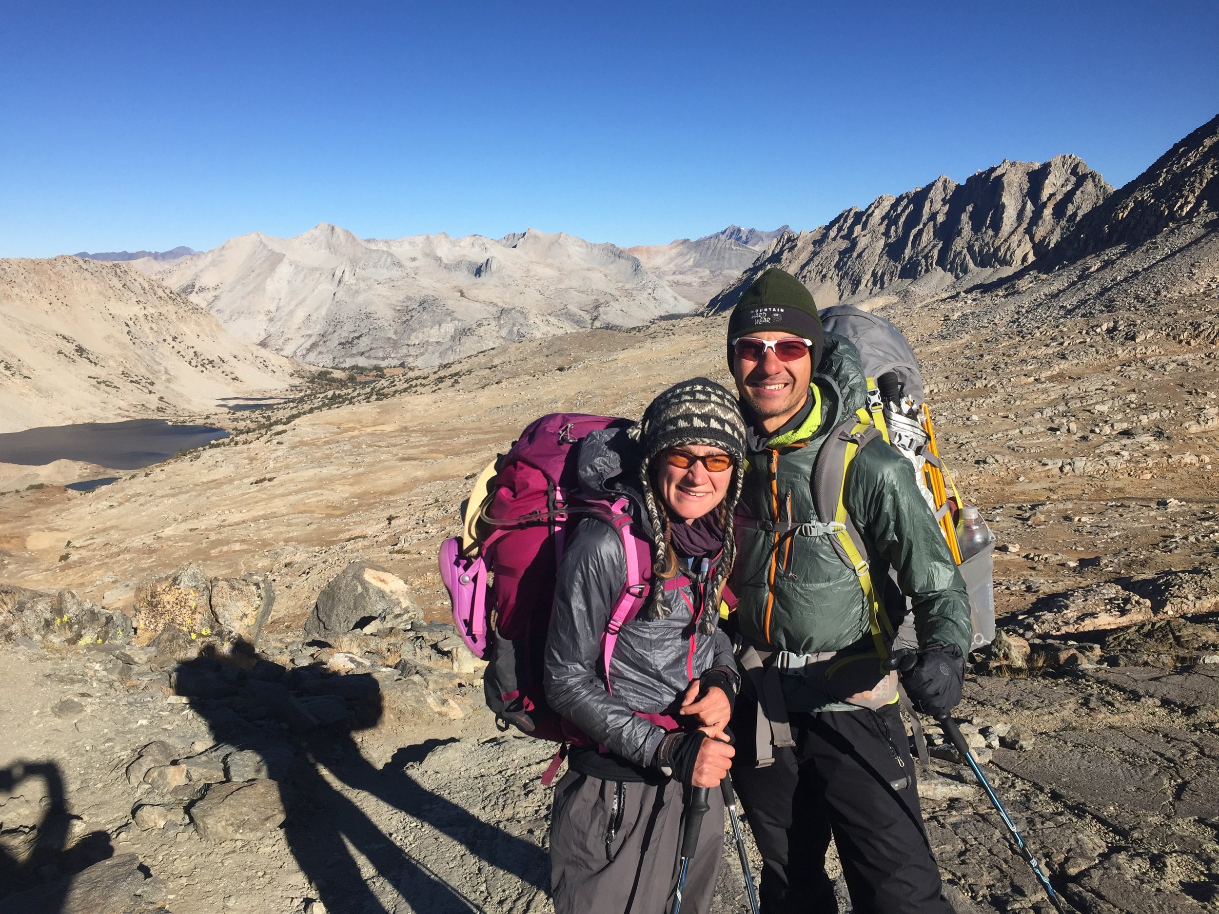
Standing atop Mather Pass in bright high Sierra sunshine on the 1st of October felt somehow monumental. We have been on the trail for nearly 3 months and have finally reached our favorite stretch of our home mountain range. We built some leisure time into our itinerary over these next few days, but taking them still feels a little risky. Although the equinox and first day of fall happened less than 2 weeks ago, there is no arguing that it is very late in the backpacking season and the chance of encountering serious inclement weather increases with every passing day. At this time of year more than ever, we have discovered that being in the high country is all about the elements.

It's only 4:30pm, but it's plenty cold at Lake Marjorie and we are about to hop into our tent for the night

The forecast called for possible precipitation, and the sky has changed rapidly as we make our final approach to Rae Lakes on Day 89 so we'll hurry to pick a campsite in case those clouds mean business. Without the sun the temperature has dropped precipitously.
Sun is everything in October. The Indian Summer temperatures of late September were already waning and definitely vanished once the calendar turned. We now start hiking in many layers every day, and stop to shed them in stages only after we are reached by direct sunlight. Depending on the height of the surrounding ridges and the aspect of our particular basin, this could be several hours after hitting the trail. The mid-day temperatures can still be pleasant, but it is no longer unusual for me to keep a long-sleeved layer on all day. Macro always has on a few layers and will probably send his running shorts home at the next opportunity as he has not worn them for days. When we stop for breaks we seek out sunny spots instead of options with shade. When the sun goes behind clouds, the temperature drops at least 15 degrees, and sometimes more. The difference between temperate afternoon and a downright chilly day is now completely dependent on the sun, and the days continue to get shorter. Despite our lower daily mileage in the Sierra, we have been caught needing to hike by headlamp the final distance to a campsite more than once. This time of year there is a big difference between daylight and sunlight. On Day 88 we had planned what we thought would be a day of wilderness leisure, hiking just under 15 miles (though this did include the entire climb of Mather Pass from the upper canyon of Palisade Creek). We reached our campsite at Lake Marjorie before 4:30pm, but the sun had already dipped behind a tall ridge which cast the entire basin in deep shadow. Rather than splash in the lake or lounge on granite to take in the scenery, we hurried to pitch our tent and rainfly as the temperature rapidly dropped from chilly but to below freezing and a stiff breeze became a strong and cold wind. Although we still had a few hours of daylight remaining, we spent it nearly entirely inside our tent since once we stopped moving that was the only way to stay warm. We also notice the sun takes a lower path across the sky than it did in the summer months. While this means cooler temperatures and greater likelihood of being obscured by the dramatic topography of this mountain range, it also provides long periods of low-angle sunlight in both the morning and the evening. This prolonged "golden hour" imparts a magical glow to everything around us, and makes it well worth the challenges of hiking through the high country in this late season.

The water level in Woods Creek is a bit low, but it is running well enough to cascade along this hillside of brilliant fall aspens

Macro crossing the suspension bridge over Woods Creek near the trail junction to Paradise Valley

A frozen creek in full sun, in late morning

There's plenty of water in Arrowhead Lake, though the level is a bit lower than usual. View back towards the north on Day 89.
Water is another important element, and one that is constantly on our minds. We keep track of water sources to use for drinking, waterways that we may have to ford, and water that might fall from the sky. In October, we have found that each of these might turn to ice. The Sierra Nevada is not known for long dry stretches, and generally has more frequent water sources than other PCT sections. Even late in the season we have found water to be plentiful. The lakes are all a bit low as evidenced by the rocks around their shores, but many streams and small creeklets are running. Compared to late September trips we've taken here in the past few years, there is much more water this year and we are happy to see it after so many years of drought. On Day 89 we passed a woman catching her breath on the side of the trail along the Baxter Creek drainage who said she was headed to Rae Lakes Basin for the night, but hoped she could find some water in the meantime. I laughed, assuming she was joking, and said there is plenty of it around, but then she proceeded to ask me where to find it. She had camped last night above a river but felt it was too far below to access, and crossed a bridge over Woods Creek but didn't think she could get to the water. She hadn't seen any water since then (less than half of a mile back) and wanted to know if I had. I had to admit that there wasn't any in this short stretch, though I think most backpackers would find both of her "inaccessible" creeks very easy to reach (I kept that thought to myself). We wished her luck and continued on, noting 3 streams with very good flow within a few yards of the trail within the next mile. She was definitely an anomaly in this water-rich section of trail. Footbridges are relatively rare in the Sierra, and numerous waterways are listed as "ford" on the maps. Many of these can be quite tricky in early season runoff, but we have only gotten wet once (crossing Evolution Creek, which, incidentally, we did in the rain - getting doubly wet) as everything else has had a low enough water level and/or sufficient rocks or logs to allow for a dry crossing. The suspension bridge (built 1988) over Woods Creek not only makes easy work of getting across what can be a significant river at some times of year, but is also a thing of both engineering and aesthetic beauty and is known as the "Golden Gate of the Sierra." No matter how many times we cross it, we always take pictures and it always makes us smile. The surface of the creek is far below the walkway of the bridge (this minimizes the danger of washout), but it is an easy walk down either shore to the water's edge and the area is a very popular campsite among JMTers and thru-hikers who obtain water from the creek for drinking. After the afternoon rains of the past few days and the predicted precipitation of the coming weekend, water from the sky is constantly on our mind. In these first few days of October we have been fortunate to have dry days, though the sky did threaten as we reached Rae Lakes in late afternoon on Day 89 and we even had some snow flurries later that evening. With the much colder nighttime temperatures and the shorter days, patches of water along the trail are frozen each morning and remain solid through much of the day. Coming down from Pinchot Pass on Day 89 ice rimmed the periphery of several smaller lakes in the upper portion of the basin, and we passed frozen creeklets as late as 11:30am even in direct sunlight. We ran into a couple making a day hike to the pass from their campsite near Woods Creek, who said their thermometer had read 24F that morning. We don't know how cold it got at our campsite near Lake Marjorie, but 2500' higher in elevation it was probably quite a bit colder. On Day 90 as we got ready to leave Upper Rae Lake, we found that our hydration reservoirs had large ice chunks in them, even kept inside our backpacks under a tree overnight. It looks like in October, the water will need to come inside the tent with us.
This is October in the high country. Despite the stiff climb and full sun at Pinchot Pass, the wind is cold and strong and we are still wearing every layer we have except for down jackets. (PC: random backpacker)

Macro coming down the north side of Pinchot Pass in a strong wind
Wind is a huge factor in our days and nights. An afternoon breeze can be pleasant, but gale-force gusts make climbing an exposed ~12,000' pass rather challenging. We have become adept at using trekking poles to brace ourselves against sudden shifts in the air that might otherwise threaten our balance. Other than routine shedding of layers as we reach direct sunlight and adding them back when the sun dips behind the nearest ridge in the afternoon, most of the temperature swings we encounter during the day and subsequent costume changes can now be attributed to the variable force of the wind. Macro gets cold easily and so far in October has worn his wind jacket for much of each day. I tend to warm up quickly when hiking and have low tolerance for heat, and yet have worn my warm hat for part of each day in October to combat wind (having only worn it once while hiking on the entire trip prior to this). The wind seems to be particularly intense at night, and is the reason that we now routinely pitch our tent with the rainfly for some protection against the gusts. It can be difficult to sleep through strong wind, and we miss seeing the stars while we lie in our sleeping bags. One small advantage to the wind is that it does cut down on condensation within the tent and we rarely have to shake ice off of the fly in the morning. But overnight at Upper Rae Lake the wind was so strong it blew layers of fine dirt through the mesh of our tent and in the morning we found ourselves and everything else covered. I think we'll be shaking it out of things until we next have access to showers and laundry.

Day 88 food: Two servings of granola for breakfast. Pro Bars, Prinal Strips, Somersaults, dried peaches, and Clif shot bloks for lunch. Annie's fruit snacks (thanks Hillair & Michael!), Justin's nut butters & Gin-Gin chews (both leftover from last stretch) are extras, courtesy of room in the bear canister. Dinner is 13-bean and barley soup, Idahoans with olive oil, miso soup. Special accompaniment of tortillas (thanks Sue!) and a chocolate bar for dessert (thanks (Cat & Thup!) since we still had a little extra space.
Is food an element? I don't think so, though it is an important part of every day. For a while, we almost had too much food (is that even possible?) due to frequent visits with friends and family along with short stretches between resupplies so that our calories weren't necessarily limited by weight considerations. Heading into Yosemite and south through the remainder of the Sierra Nevada, our food is severely constrained. Not only do we have the longest stretches between resupply of our entire trip and sight to consider, but the volume of food we carry must fit into our two bear canisters. For these sections we've largely abandoned variety (other than different flavors of some item) and have reverted to what we know works from many previous trips with similar constraints. Our breakfasts are still granola with powdered milk and fruit, but the fruit is freeze-dried (vs just dried), the granola is selected to be the most calorie-dense per volume, and each person/day ration is portioned out in an individual ziplock bag. Snacks follow the same general scheme as before but there are no duplicates or extras, and little variety. Every day the bar is a ProBar, for the most calories per volume. The protein is always a vegan jerky Primal Strip because they are thin and fit well in the canister with no wasted space. The only "crunchy" we bring is one bag of Somersaults each day, repackaged into ziplocks to optimize volume. These little round sunflower-seed based crackers don't crumble, are high in protein and calories, and pack with minimal air space so they have become our go-to carb for long backcountry trips. Clif shot bloks meet our requirements, and we have two packages a day between us. Dried fruit is one area we see a little variety, though we do pre-portion daily servings and cram any air out. Each night we have instant miso soup, a package of Idahoans, and a dehydrated dinner (we only bring meals that pack with no wasted air space in these sections, though every night is a different entree). Olive oil adds calories and I put most of the packet on Macro's food due to his higher metabolism. With any spare space we'll stuff in a few treats, usually consisting of dark chocolate (M&Ms work better than bars because they fit well in canister crevices). We are fortunate that Hillair and Michael met us at Red's Meadow, since this decreased our canister food carry by two days and subsequently allowed us to squeeze in some high-value extras like cheddar cheese, tortillas, more chocolate, and additional olive oil. Even with these additions we definitely notice the decrease in our caloric intake. If we are careful to spread the available calories throughout the day, we don't feel obvious hunger. Even so, we are looking forward to the return of more varied and plentiful dining options south of the Sierra Navada.

Above tree line in Upper Basin, south of Mather Pass

The peaks of Lake Basin (L), golden and treeless Upper Basin (R mid-field), and Mather Pass from the south with the Palisade Crest visible beyond (R above Upper Basin) . Taken from the climb away from the South Fork Kings River

Crater Mountain, across the valley from Mt. Cedric Wright
Mather Pass to Rae Lakes Basin on the JMT/PCT marks a stretch of the Sierra Nevada that we have visited countless times. Although we rarely hike many miles on the trail itself, we use it for access to the broad trail-less area of the Kings Canyon high country bounded by Palisade Creek to the north, the JMT/PCT to the east, and Woods Creek to the south. Walking this section of trail brings to mind previous trips and as we pass familiar peaks in the adjacent basins we reminisce about some of our favorites. Coming down from Mather Pass through Upper Basin in the golden low-angle October sunlight, we eyed steep and tricky Frozen Lake Pass and were glad it wasn't today's destination with the strong and biting wind. As we crossed the South Fork Kings River we recalled a trip that crossed Cartridge Pass, the old route of the JMT before the trail over Mather Pass was constructed in 1938. Passing the lateral to Bench Lake we were even tempted to hike the 1.5 bonus miles each way just to camp at this lovely spot that has been the jumping-off point for many off-trail adventures in the region. Instead, we reminded ourselves that it is already October, we still have to make it over Forester Pass, we would like to summit Mt. Whitney, and there is plenty of high country to walk through without adding on any extras. Oh, and we have that zero day planned... As we pass Twin Lakes under the shadow of Mt. Cedric Wright, we are reminded of a trip where we woke there to several inches of snow on our tent on the day of the fall equinox. We remember the spot along Woods Creek where there are three Foxtail pines standing alone on a small plateau, the first example of this unique tree on a southbound JMT hike. As we continue our descent along Woods Creek we know the spot where we can look up to see the tip of Window Peak. We scan the hillside together and identify the drainage we followed descending from its eponymous lake on one particularly magical trip. This region of the Sierra with its rugged peaks, high passes, sparkling lakes, sparse but tenacious windswept trees, and deep blue sky are spectacular by any estimation. We feel an especially close connection to these mountains as we connect our current journey to those in our past. Our late-season travel brings many challenges, but it also offers great natural beauty in the transition from summer to winter. We might not otherwise choose to walk from one end of the Sierra to the other this late in the year, and feel fortunate that our thru-hike has afforded us the opportunity to see some of our favorite places in a different season and light.

Foxtail pines on the climb up the Baxter Creek drainage towards Rae Lakes Basin
Fun Fact: The southern Foxtail pine (Pinus balfouriana) is a distinctive conifer that is native only to a tiny stretch of the high country in the Sierra Nevada mountains of California. This 5-needled pine is closely related to the ancient Bristlecone pine, the oldest known living thing on earth. It is thought that southern Foxtail pines can live up to 3000 years, in contrast to the much younger northern Foxtails of the Klamath forests that live only 1000 years or so. The name foxtail (also sometimes called bottlebrush) comes from the bushy appearance, as the needles grow thickly all along the length of a branch. With an intense red-brown and deeply grooved bark, thick trunks, and often unruly branch configuration, this tree is easy to recognize and is often considered the "poster child" of the southern Sierra high country. It is found only in the region of Sequoia & Kings Canyon National Parks, and usually grows just around treeline. It often shares these exposed slopes with Lodgepole and/or Whitebark Pines. Southern Foxtail pines have a habit of forming grotesque shapes, with silhouettes that resemble Medusa or something out of a Halloween tale. It is always a treat to walk through a grove of Foxtails, knowing how rare they are.

Palisade Creek cascading over rocks from the lowest shelf in the canyon, where we would soon pass the campsite of SOBO Buena Vista and his JMTing crew
We hadn't seen any SOBOs since leaving Cookie in Mammoth, and wondered how the others are faring especially with the short days, cold nights, and high elevations. After a few days of moderately high mileage to reach Mather Pass, we planned relatively short hiking days of ~15 miles to allow more time to enjoy our favorite stretch of the high country. We assumed that those ahead of us would get further ahead, and perhaps some from behind us may pass by, but thought we were aware of who was within a few days of us in either direction. While enjoying the sun at the top of Mather, we were surprised to meet a completely new SOBO. The threesome of JMTers we met starting up the "golden staircase" turned out to be a foursom, including a SOBO. Buena Vista started more than a week ahead of us, and is the first SOBO we've heard of this year who says he hiked in straight from Canada (which is officially prohibited). He had remained comfortably ahead of us until his wife and another couple joined him for the JMT section, which they are taking "one pass at a time." This slowdown meant that even with our moderate mileage, we are covering in one day what they hike in two. They had seen Pitbull, probably a half-day ahead of us, and a few other SOBOs ahead of him that we haven't yet met. None of the ones we know to be behind us seem to have passed by. He asked if we'd seen Cinch & French Fry, who he'd hiked with before the Sierra, and we filled him in with what little we know about her evacuation from Dorothy Lake (apparently due to giardia). Although we love solitude in our mountains, we are also part of a community and as the SOBOs have become more spread out we are even more interested in maintaining contact with the others. With no trail registers or town stops in this part of the Sierra and no cell service, other hikers and word-of-mouth are how we keep up. Buena Vista and friends plan to resupply in Independence via Kearsarge but will not zero, and his friends will leave the trail via Whitney Portal after summiting Mt. Whitney. This is close enough so that once his mileage returns to normal thru-hiking levels we may cross paths again. That's one more SOBO to add to our little circle of connected hikers.
We are just two passes shy of Mt. Whitney and from there we will enter uncharted territory, as we have never hiked the PCT south of that point. We still plan to zero out of Kearsarge Pass (between Glen and Forester) with our friend Cynthia, though we are now leaning towards spending that time in Bishop rather than the tiny town of Independence. We will take the weather and conditions one day at a time, and are certainly not the only ones in these mountains in early October. We hope that once we are south of the challenging high country of our beloved Sierra Nevada, we will reconnect with the other SOBOs that we have come to know throughout this amazing journey of ours.
- Huckleberry