Tacoma Pass to Big Crow Basin (29.9 PCT miles)

So many mushrooms in WA, whether in managed or natural forest
We crossed the nearly-paved road marking Tacoma Pass and started our climb (like many passes on the WA PCT, the pass marked a low point on the trail rather than a high point). We were pleased to enter natural forest, for the first time since passing Mirror Lake early yesterday. The variety of species, ages, and diameters of the conifers and the mix of ground cover plants adapted to deep shade were quite a contrast to the "Christmas tree forests" of various ages we had been walking through for miles in this region of forest land managed for timber production. We also appreciated the deep, cool shade on an otherwise hot and sunny day. After the first 300' of climbing there was a side trail to a stream, the last water on trail for nearly 12 miles. We didn't need any but briefly chatted with a section hiker resting there who had started in Yosemite on June 1 and was headed to the Canadian border. From there we continued on to start what would be about 6 miles of climbing, gaining ~2300' of elevation.

In a managed timber forest, checking for PCT signs is a nice diversion. This one was sideways, behind some branches, on an old stump. Probably not to code!
Sadly our dense natural forest only lasted for a single slope. For the rest of the climb we were in and out of managed forests, across abandoned jeep tracks, and through dry rocky sections. We did enjoy increasingly frequent views of Mt. Rainier to the south, and the snow-capped Cascades to the north. Wildflowers were plentiful, as were ripe huckleberries. Despite the heat we found the climb reasonably civilized. We ran into one casual hiker and commented on the relatively "ho hum" nature of this section, other than some distant views. He assured us that Norse Peak further south would "blow our minds," so that gave us something to look forward to. From the high point of Blowout Mountain, we started a long gradual descending traverse to a spring-fed creek that marked the end of our waterless stretch. It was nearly 6pm by the time we arrived, and we found a WA section hiker camped there for the night. He told us 5 SOBO thrus had just left, planning to stay at the cabin. We filled up with water, had a snack, and headed down the trail for the final 3 miles to the campsite that Marty McFly had recommended. The first mile climb was a drag weighted down with the extra water, but at least it was gradual. From there we crossed a saddle and entered an old burn zone. An informational sign erected by a local scout troop told us the fire occurred in 1988, nearly 30 years ago. The bare snags made a gorgeous contrast against the evening sky, but it was shocking to us that there were only a handful of trees growing in the burn area, and these were only 3-5' tall. We wondered why the forest hadn't started to regenerate more effectively. Past the burn we traversed the slope of Pyramid Peak to reach our campsite, a dead end gravel road with an unobstructed view of Mt Rainier, just as the sun was setting. The wind had picked up through the afternoon and was quite strong, but at least there were no bugs. We enjoyed dinner while watching the last light of day on the massive mountain, and set up our tent with the fly folded halfway back as the sky was clear.

Our tent hangs out in the most beautiful places, and even makes an abandoned road look pretty
Speaking of our tent, we are hiking with our Mica FL2 from The North Face. It is a compact and ultra-lightweight 2-person tent, but roomy inside and has 2 vestibules which makes if feel twice as large. We've had the tent for a few seasons and absolutely love it. You can go lighter with a single-wall tent, a tarp-tent, and/or a shelter that requires trekking poles to pitch. But for a self-standing double-walled tent, it is the lightest weight best-featured tent around. In the first week of our hike we noticed the attachment points between the fly and the tent were coming loose, and over the course of several days they all came off of the fly altogether. We tried a field repair at Stevens Pass with super glue, but all but one failed again within a few days. The tent was still keeping us dry, but the fly was very unstable in the wind. From Snoqualmie Pass on Day 18 we sent an email to our friend Ann (who works for TNF) asking for her help in connecting us to the right department for repair advice. By the next morning, before we hit the trail she'd passed our email along to their gear guy Todd. And at our road's end Rainier view campsite 2 nights later we had enough cell service to find out by text message that TNF will overnight a replacement tent to us at our next stop, wherever we think would be best to pick it up! I love a company that stands behind their gear, and send a huge shout-out to Ann who helped facilitate this quick solution. Our shelter is hugely important to us on this thru-hike, and we are looking forward to having a fully functional stormfly.
On that note, many people have asked what we think about our gear and clothes choices. We've been very pleased so far. We've never gotten wet in our tent (in contrast to many hikers in lighter-weight shelters), and our sleeping bags have kept us warm. We each started with 2 pairs of gloves, and gave up our fleece windproof pair as we realized that the waterproof/windproof pair is sufficient. All of the other clothing we've carried has been worn and appreciated. Andrew is having another warm long-sleeve layer sent to White Pass, as he tends to get cold. We are both looking forward to a new pair of shoes there, too. In all of the rain of our first 2 weeks, we discovered that a few of our dry bags are no longer 100% effective, so we've made replacement plans. With regards to snow gear, we started with tall gaiters, ice axes, crampons, and snow poles. We gave up the gaiters at Rainy Pass and switched the crampons for microspikes. We gave up the microspikes at Stevens Pass, and will give up the ice axes at White Pass where we will also trade out snow poles for our lightweight trekking poles. We kept snow gear this long because we were unable to get good trail condition information, but wish we had given all of it up at Stevens as there have only been a few very small snow patches across the trail since then. We probably wouldn't start with tall gaiters next time, as post-holing is less of a concern than traction.

Macro enjoys first morning light on Mt Rainier from our roads-end campsite
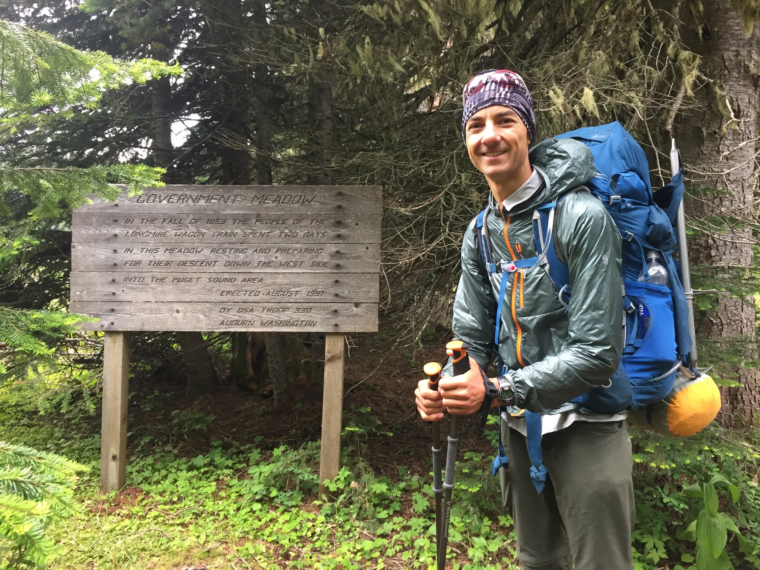
Government Meadow. Seems that many WA scouts get their eagle ranking by posting informational signs along the PCT
Day 21 dawned misty and windy. The tent fly was soaked with condensation, and there was a thick mist blowing up from the valley below. We were elated to find that this didn't obscure our front-row view of Mt. Rainier, and we enjoyed our coffee/tea and breakfast sitting out on the edge watching the sunlight hit our private mountain. It's always a hassle to pack the tent wet, but at least it wasn't raining. It was a few mile wooded descent to Ulrich Cabin at Government Meadow, and we dropped into the fog soon after leaving our campsite. We arrived at the meadow to find Ben (Sherpa) & Nuthatch just wrapping up their morning chores. They confirmed that the other three SOBOs from the creek last night were Spice Rack (the hiker formerly known as Clementine), Candy Cane, and Crusher, 3 of the girls we had camped with in Park Lakes Basin. Old School, the 4th, has gone off trail due to foot issues and may come back as a section hiker later in the season. The girls had apparently gotten an early start with a goal of hiking 27 miles to commemorate Spice Rack's birthday of the same number. We continued on past the snowmobile staging area near the meadow. From there, we skirted the Norse Peak Wilderness and the forest became remarkably more varied than what we've been walking through, with no more dirt roads or evidence of logging operations. We also found the blowdowns Marty McFly had warned us about - he'd counted 50 and it seemed they were mostly centered in the area beyond the meadow. Fortunately most were relatively small and not in clusters, so we found them easy to navigate.

Nearly 30-year old burn area, from a fire started by logging operations at Windy Gap (thanks, Eagle Scout project, for informational sign)
This would be our 3rd of 4 straight 20+ mile days in a row, and while the terrain is relatively gentle it is still nice to see that the hiking seems easier and the recovery is quicker. Day 21 also marks the longest backpacking trip we have ever done (our previous record was our 20-day John Muir Trail hike in 2007), so we are heading into uncharted territory. It is exciting to see that our aches and pains are diminishing as the days and miles continue. I took a tumble down a steep wet vegetated slope on Day 12 while trying to navigate a tricky blowdown and wrenched my knee. It was very painful at first, and I worried that it might be a trip-altering injury. Fortunately it turns out that it felt better when moving and worst after periods of rest. So I had several rough nights and difficult rest breaks, and took plenty of ibuprofen. But it is already nearly back to normal despite some pretty high-mileage days in the interim. I am much more careful with my footing at the end of the day now.

Strange sandy formations on a slope as we climbed from Government Meadow to Louisiana Saddle
We ran into a father-daughter couple at Louisiana Saddle that were out for a weekend trip. The guy thru-hiked the PCT NOBO in 1979. He told us that was the only way you could do it in those days, and recalled that of the 300 hikers who registered, only a dozen finished. We talked about our reasons for going SOBO, and he quipped that "nobody believed the guy who wrote the book about going south in the 70's, it just couldn't be done." His daughter rolled her eyes. I'm assuming he's referring to "The High Adventure of Eric Ryback: Canada to Mexico on Foot," widely considered to be a true account of Eric's southbound thru-hike of the nascent Pacific Crest Trail in ~1971, before the trail was even completely constructed. Whether true or not, it is a good read. It's been out of print for years but our local library was able to get me a copy and I recommend it. As the pair was leaving, Sherpa and Nuthatch came up so we stayed a bit longer to catch up with them. We all hit the trail together but as usual they immediately left us in the dust, and we wouldn't see them again today.

Mt. Rainier pops up around every other turn
The miles rolled by today despite the heat. We did plenty of high traversing, on alternating forested slopes and bare exposed slopes of sand or volcanic rocks. We enjoyed near-constant views of Mt. Rainier, appearing as a white hulk in the unlikeliest of spots. We joked that sometimes it looked as though someone had screwed up a paint-by-numbers picture and added a giant glacier-covered mountain behind a gentle green slope.

How Macro got his trail name
Also, in this section we adopted trail names. I am Huckleberry, for my inability to pass these wild blueberries that are so prolific along the PCT without a little hike-by harvesting (or sometimes a lot). Andrew is Macro, for his habit of getting up-close and personal with spiders, dew-drops, and wildflowers to use his phone as a macro lens in capturing his signature pictures of these tiny details.

Macro selects a tortilla spot along this spring-fed creek in Big Crow Basin
By early afternoon we reached Big Crow Basin, a high & rolling valley below dark, blocky Norse Peak. Covered in green with patches of trees, a riot of wildflowers, and a handful of spring-fed creeks, it didn't "blow our minds," but is by far the most picturesque spot we've seen since leaving Snoqualmie Pass 3 days ago. We had a long break in a sloping meadow to enjoy a lunch of spicy hummus on our favorite tortillas from home (thanks to Sue, who sent our very first care package to the Summit Inn!).
- Huckleberry